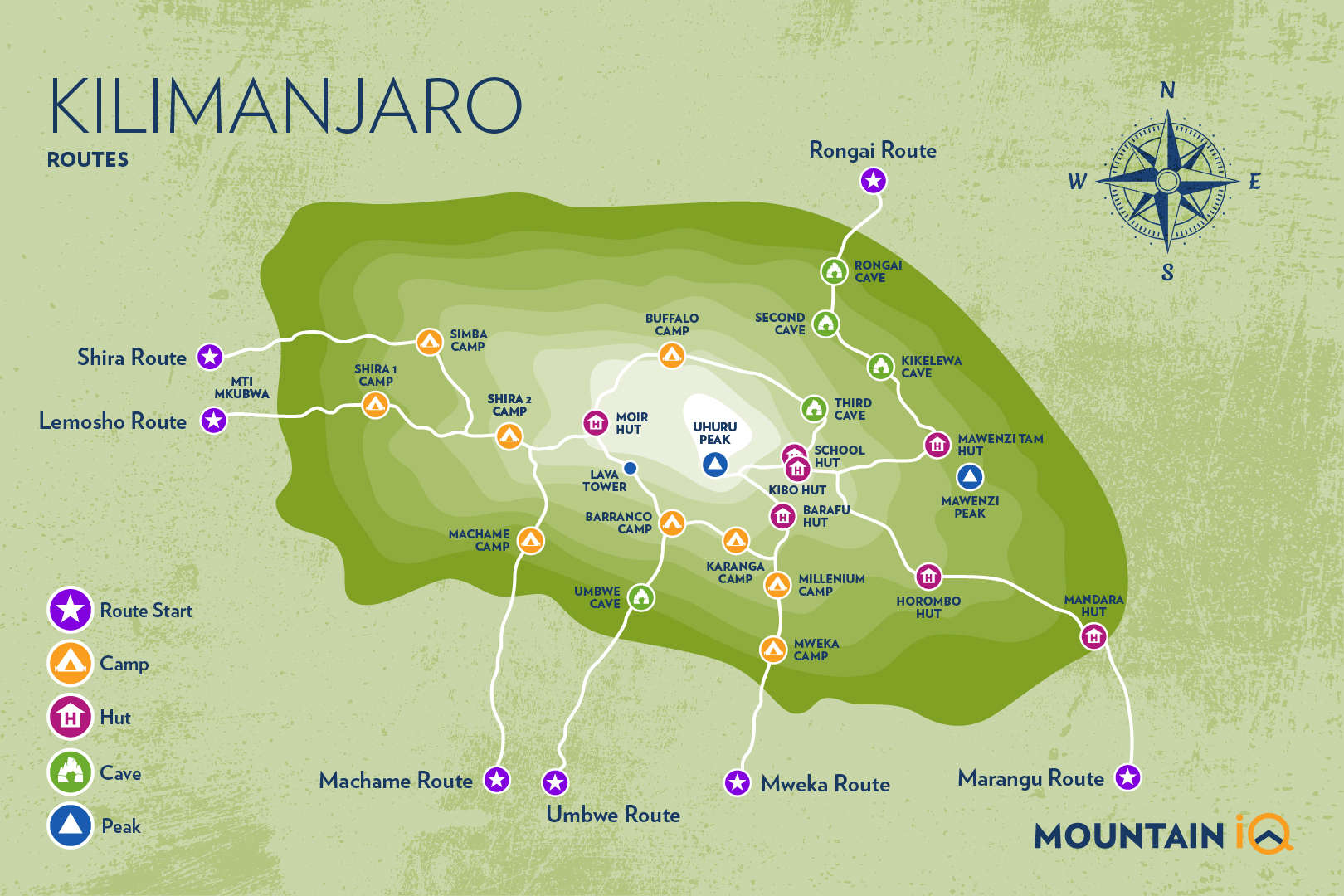
Looking at the Kilimanjaro map below, you can see that there are 7 routes to reach the summit of Mount Kilimanjaro.
The route that one chooses is important as it impacts the cost to climb Kilimanjaro, duration and potentially your chance of summit success.
As you can see on the map, three routes begin on the south side of the mountain at just under 2,000m. As you start climbing, you might just be able to see some of the diverse wildlife at Mount Kilimanjaro National Park on your way up.
Please Note: The Mweka Route is for descent only.
The Rongai Route provides a more remote passage, which begins on the North East side of the mountain. The Shira, Lemosho and Northern Circuit routes begin on the west side of the mountain.
Get a Kilimanjaro trek quote
These are the companies I recommend...
Kilimanjaro Map and Routes
Study the map to have a look at the various Kilimanjaro campsites that you will be staying at on your chosen route. Don't forget to also check out weather conditions before your trek.
Please Note: the Marangu Route is the only route that has huts for the full duration of your Kilimanjaro trek.
See this Kilimanjaro routes article to get a full overview of each trail, including detailed information on the camps and pros and cons for each route. You will also find useful altitude profiles for each of the routes. The better you understand your route and the distances between camp sites, the more likely you are to pace yourself correctly on each trekking day.
See more in our guide on climbing Kilimanjaro without a guide.
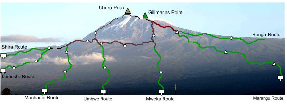
Kilimanjaro Map – Cross section
The cross-section map below gives a good sense of elevation from each of the Kilimanjaro route and their starting points.
Kilimanjaro Map – Route summary
There are seven main routes on Kilimanjaro. Three approaches from the south –Machame, Umbwe, Marangu, and three approaches from the West – Shira, Northern Circuit and Lemosho (the latter is relatively new and far superior to that of Shira which starts at a high elevation, therefore making the acclimatization process much more challenging).
A popular route, the Rongai, approaches from the drier North East.
As you climb Kilimanjaro, you will pass through four climatic zones. The first zone is characterized by tropical rain forest. At about 3,000 meters, this gives way to a moorland setting. At 4,200 meters, the landscape becomes desert-like until reaching the uppermost reaches of the mountain which are glacial.

Hi,
Hope you are well.
I was wondering what the schedule is for the Lemosho or Machame routes for late August? Early September.
Kind regards,
Marcos
Hi Marcos, August-September is a great time for both routes. I recommend checking out Skyhook for dates: https://www.skyhookadventure.com/go/climb-kilimanjaro
I climbed Kilimanjaro 50 years ago, in May 1972. We were the last party up before cloud cover closed it for the season. On the third morning we left the top hut at 1 am – a Canadian guy with his guide, a Swiss guy with his porter and guide, and my guide and I. The Canadian had to turn back because of altitude sickness not long after we started but the Swiss guy and I made it to the summit at 9 am by which time the cloud cover was very low. To descend to the top hut, the Swiss guy sat on his haunches and skied off down the icy slope. Coming from inland Australia with no experience of snow, I did the best I could to follow. We made it back to the bottom in two days – the organisers of the climbs were not happy with our guides for being so speedy. We were given a halo of everlasting daisies to mark the occasion which I kept. Sadly the flowers have all disintegrated except for a few petals of the last one.
Your site is amazing for its clarity and inclusiveness. You are doing such a good job. Thank you.
Jenny
Fantastic story Jenny. Kilimanjaro 50 years ago must have been amazing! Thanks for sharing.
Hi,
Noticed that you put the wrong name on Machame route on the top map. You wrote Shira route twice.
Kindly
Tomas
Thanks for the heads up Tomas, we’ll get that corrected!